Home - Clean & Back - Day 20
Today I had lots of miles to traverse, but no set times to meet anybody, so I was able to enjoy the awe-inspiring scenery along the route without distractions like clock-watching. The steep climb up the Rockies begins just about at the western edge of the Denver metropolitan area, so I got pretty deep into the throttle almost immediately. This was the day I got both the best and the worst fuel economy I've ever seen; climbing a 7% grade at freeway speeds in this thin air requires the pedal to be against the firewall, and you can almost watch the fuel gauge drop! On the other hand, heading down a 7% grade on the other side of the mountains, I didn't hear any ticking from my fuel-pressure regulator for miles on end, as the injectors just ran off the residual pressure in the fuel rails from the preceding climb without needing to add any from the tanks. Spooky--you aren't quite sure the engine is still running...
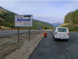
I said yesterday that I expected Vail Pass to be the highest point I reached; actually, the highest point along I-70 is through the Eisenhower/Edwin C. Johnson Memorial Tunnel at 11158 feet elevation. There was nowhere safe to stop for a nice "touristy" photo of that, but immediately on exiting to the west you enter the aptly named Summit County. I wish I had brought along my large-format camera and had a week or three to look for good vantage points; a 640x480 pixel JPEG (or the 320x240 ones I usually post...) shot from the side of the road just can't begin to do justice to the grandeur of the mountains.
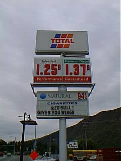
I stopped at three Natural Fuels Corp. stations after I left Denver, in Silverthorne, Glenwood Springs, and Grand Junction. I could have skipped any one, or possibly two, and not run out of fuel, but since I wasn't sure just when the uphill grades actually were going to end, I decided not to pass up the opportunities to top off. Here's the sign on the Total station in Glenwood Springs; note the healthy price differential between natural gas and regular gasoline.
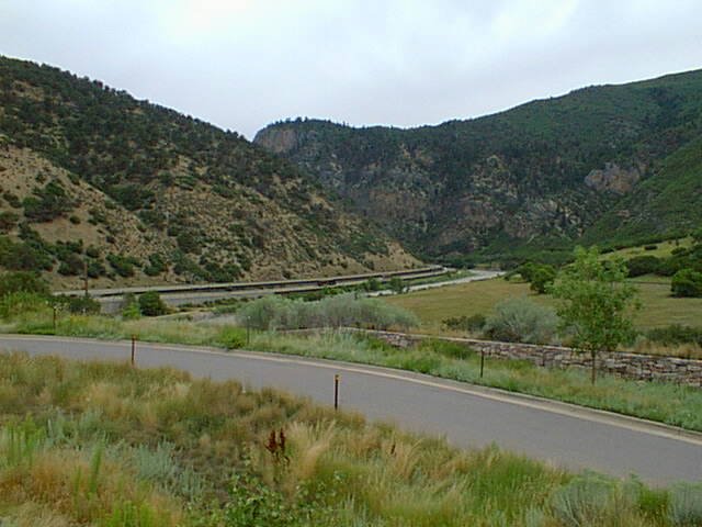
I wanted to show one photo of the view along the way, just to give you an idea of scale if you've never been there. This is a photo of the west end of Glenwood Canyon, taken from the No Name rest stop (yes, that's what it's called); again, there wasn't much in the way of safe places to stop and take photos in the most interesting parts of the canyon. You can see the Colorado River exiting the canyon, and to the left (north) of it you see I-70, two lanes in each direction, with the westbound lanes slightly uphill from the eastbound lanes. What you can't see are the bike path and all the raft access points; I saw more rafts running the mild whitewater than I knew existed! There's also a railroad on the south bank of the river, one track for each direction (east and west). When the canyon gets narrow, you wonder how the heck they cram all that in there! The answer is that the river gets pretty much covered over by the highway; at least, I lost sight of the river completely in the tight spots. I-70 never drops below two lanes in each direction as a concession to the tight fit, though!
Once out of Glenwood Canyon, it's a relatively gentle downward slope most of the way into Utah; I had a nice brisk tailwind, too. The plain that you finally end up in reminds me of some of the high desert I've seen in California: lots of scrub, and wide-open horizons. I have never before today seen the entirety of a thunderstorm all at one time! In the plains I've traversed on both sides of the Rockies, where you don't have much by way of hills, trees, or buildings between you and the horizon, you can watch distant areas of rain moving like veils across the land; today I saw a thunderstorm, looking more like curtains than veils below a heavy cloud with a vanguard of scud in front of it, and I could watch it move toward me by seeing how the rain obscured successively closer ridges in the canyons that border the plain. I really pitied the motorcyclists going along I-70 whom it was going to catch up with; I turned north on US Highway 6/191 in front of the storm, and only got a little of the leading edge of the rain. Again, I wish I could have set up my large-format camera and tried to capture the immense cloudscape and the progressive conquest of the ridges by the walls of rain!
I reached Price, UT, where I'll be spending the night, early enough to make a few phone calls to prepare for the weekend's stops; before I did that, though, I stopped at a Texaco station in town to refuel (I probably didn't need to in order to make it to the next station toward Salt Lake City tomorrow, because of that tailwind, but you can never have too much insurance, right?). I paid about fifty cents less for a gasoline-gallon-equivalent of natural gas than I would have for cheap gasoline--this is, I think, the biggest price spread I've seen on this journey!
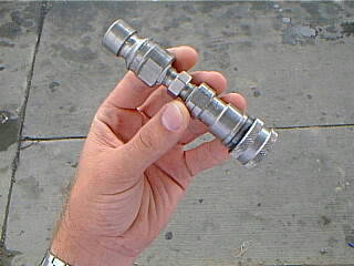
A couple of days ago I showed the adapter I used at the few refueling stations where the only nozzles were made to the Hansen connector standard, such that they wouldn't fit on my NGV-1 standard vehicle fitting. At the Texaco station in Price, they had in a pocket attached to the dispenser an adapter of the opposite sense: this is what you use if your vehicle has a Hansen connector and you want to refuel at Price or another place that has NGV-1 nozzles. That thing I'm holding in the photo isn't cheap to make; it's kind of nice they feel secure about leaving it right there at the dispenser, out in the open. Another nice thing about Utah travel is that they have pretty high standards for roads: I saw some signs in a couple of places that said "Road Damage Next (xx) Miles", but the road was certainly in no worse shape than I had been encountering in many places all through this trek. If those are damaged roads, I'd like to see what they consider a pristine one!
 To
Day 21
To
Day 21 Back
to "Clean Across America And Back"
Back
to "Clean Across America And Back" Back
to Fueling Station
Back
to Fueling Station Site
Map
Site
Map Contact
Me
Contact
Me
![]()
![]()
All content copyright 1998-2026 by Mark Looper, except as noted. Reuse of my copyrighted material is authorized under Creative Commons Attribution 4.0 International license (CC BY 4.0).
![]()
![]()
new 21 August 1998, revised 22 August 1998